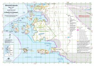
Map 14614: Windmill Islands : Map 2 of 5
Map details
| Map Number | 14614 |
| Title | Windmill Islands : Map 2 of 5 |
| Edition | 7 (Out of Date) |
| Previous edition | [Previous edition : 6] |
| Next Edition | [Next Edition : 8] |
| Scale | 1 : 50 000 |
| Publication date | September 2017 |
| Publisher |
Australian Antarctic Division (Australia)
|
| Spatial coverage |
(110.3681° -66.2778°)
,
(110.6722° -66.2778°)
,
(110.6722° -66.3944°)
(110.3681° -66.3944°) |
| Projection | Universal Transverse Mercator |
| Physical size | 29.7 x 42 cm A3 |
| Notes | . |
| Keywords | Bailey Peninsula , Mitchell Peninsula , O'Brien Bay , Beall Island , ASPA 135 , ASPA 103 , Robertson Channel , Cronk Islands , Shirley Island , Sparkes Bay , Hiegel Passage , Penney Bay , Ardery Island , ASPA 103 , Odbert Island , Pidgeon Island , Warrington Island , Midgley Island , Hollin Island , Borrello Island , Casey Ski Landing Area , Mitchell Peninsula Unrestricted Travel Area , Mitchell Peninsula Field Landing Site , Station Operational Area , Sea Ice Travel Boundary , Topographic |
Downloads
This is a digital map available for downloading.
Map Lists
No maps lists available.
Additional Information
| Horizontal datum | WGS 84 |
| Vertical datum | Mean sea level |
| Vertical unit | Metres |
| Magnetic variation | Magnetic North is 101 degrees west of True North |
| Nomenclature | Australian Antarctic Gazetteer |
Preview