Macquarie Island - extended list
View All Map ListsAn extended list of maps of Macquarie Island including maps of Macquarie Island Station.
Showing 1 to 20 of 42 maps. On page 1 of 3, go to the Next Page
ANARE Macquarie Island
|
Annex B: Macquarie Island Spill Risk Assessment Map
|
Australian Exclusive Economic Zone: Macquarie Island East View Map Details
Map ID - 13283
Published On - July-2006 Scale - 1 : 1 000 000 Physical Size- 118.8 x 82 cm 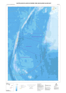
|
Australian Exclusive Economic Zone: Macquarie Island West View Map Details
Map ID - 13302
Published On - August-2006 Scale - 1 : 1 000 000 Physical Size- 118.8 x 82 cm 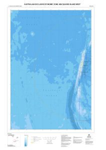
|
Australian Exclusive Economic Zone: Macquarie Island West View Map Details
Map ID - 13282
Published On - July-2006 Scale - 1 : 1 000 000 Physical Size- 118.8 x 82 cm 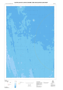
|
Australia's Maritime Jurisdiction around Macquarie Island View Map Details
Map ID - 14006
Published On - 2010 Scale - 1 : 1 250 000 Physical Size- 107.5 x 84 cm 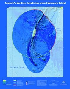
|
Australia's Maritime Jurisdiction around Macquarie Island View Map Details
Map ID - 14003
Published On - 2010 Scale - 1 : 1 500 000 Physical Size- 107.5 x 84 cm 
|
Geology of Macquarie Island View Map Details
Map ID - 5122
Published On - 3-June-1998 Scale - 1 : 50 000 Physical Size- 85 x 60 cm 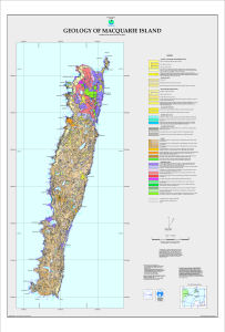
|
Geology of Macquarie Island - North View Map Details
Map ID - 5120
Published On - 28-May-1998 Scale - 1 : 25 000 Physical Size- 88 x 68 cm 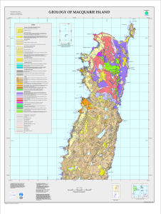
|
Geology of Macquarie Island - Sheet 1 View Map Details
Map ID - 5113
Published On - 18-March-1998 Scale - 1 : 10 000 Physical Size- 73 x 88 cm 
|
Geology of Macquarie Island - Sheet 2 View Map Details
Map ID - 5114
Published On - 18-March-1998 Scale - 1 : 10 000 Physical Size- 70 x 85 cm 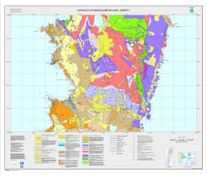
|
Geology of Macquarie Island - Sheet 3 View Map Details
Map ID - 5115
Published On - 18-March-1998 Scale - 1 : 10 000 Physical Size- 73 x 88 cm 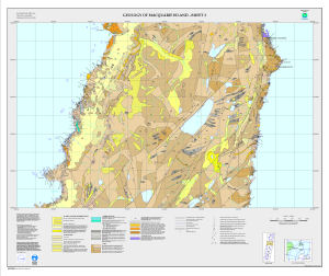
|
Geology of Macquarie Island - Sheet 4 View Map Details
Map ID - 5116
Published On - 18-March-1998 Scale - 1 : 10 000 Physical Size- 73 x 88 cm 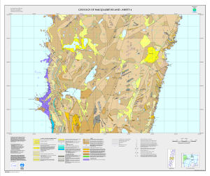
|
Geology of Macquarie Island - Sheet 5 View Map Details
Map ID - 5117
Published On - 18-March-1998 Scale - 1 : 10 000 Physical Size- 73 x 88 cm 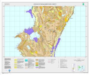
|
Geology of Macquarie Island - Sheet 6 View Map Details
Map ID - 5118
Published On - 18-March-1998 Scale - 1 : 10 000 Physical Size- 73 x 88 cm 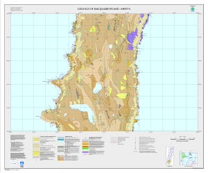
|
Geology of Macquarie Island - Sheet 7 View Map Details
Map ID - 5119
Published On - 18-March-1998 Scale - 1 : 10 000 Physical Size- 73 x 88 cm 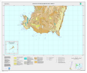
|
Geology of Macquarie Island - South View Map Details
Map ID - 5121
Published On - 13-March-1998 Scale - 1 : 25 000 Physical Size- 88 x 68 cm 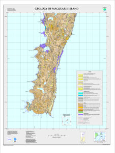
|
Location of Macquarie Island in relation to Australia and Antarctica [Black and white] View Map Details
Map ID - 13143
Published On - May-2005 Scale - 1 : c139 928 200 Physical Size- 4.5 x 5.5 cm ![Location of Macquarie Island in relation to Australia and Antarctica [Black and white]](/database/mapcat/maccais/macca_location_bw_thumb.jpg)
|
Macquarie Island [Black and white A4] View Map Details
Map ID - 13265
Published On - April-2006 Scale - 1 : 150 000 Physical Size- 29.7 x 21 cm A4 ![Macquarie Island [Black and white A4]](/database/mapcat/maccais/macca_A4_bw_13265_thumb.jpg)
|
Macquarie Island [Black and white] View Map Details
Map ID - 13141
Published On - May-2005 Scale - 1 : c661 160 Physical Size- 5.7 x 3.8 cm ![Macquarie Island [Black and white]](/database/mapcat/maccais/macca_island_bw_thumb.jpg)
|
Showing 1 to 20 of 42 maps. On page 1 of 3, go to the Next Page