Argos Satellite Tracking
 System Overview
Most of this was taken from the PDF file on the Argos home page and then converted to hypertext by Dave Watts circa June 1996.
Contents
Introduction
Argos is a satellite-based system which collects environmental data from autonomous platforms and delivers it to users worldwide. Argos has truly global coverage and is fully integrated providing data from the source to the User's desktop. Telemetry from User platforms is also used to calculate geographic position to within 150 to 1000 meters. Currently, over 5,000 transmitters are operating in a variety of applications involving either study of the earth or protection of the environment.
The Argos system has been operational since 1978. It was set up under an
agreement (Memorandum of Understanding) between:
-the National Oceanic and Atmospheric Administration
(NOAA, USA),
-the National Aeronautics
and Space Administration (NASA, USA),
-the the French Space Agency (CNES).
Argos is operated and managed by:
-Collecte, Localisation, Satellites (CLS),
a CNES subsidiary in Toulouse, France,
-Service Argos, Inc., a CLS North
American subsidiary, in Landover, near Washington, DC, USA.
Argos is easy to use. Your transmitter starts sending signals as soon as you switch it on. One of the system satellites collects the data and retransmits it to the Argos centers for processing. Accessing your data is just as easy. You can retrieve your results from anywhere in the world by public data networks, often within 20 minutes of transmission.
Another attractive feature of the Argos system is the small transmitters:
-average daily power consumption is as low as a few milliamps,
-miniaturized models can be as compact as a small matchbox, weighing as little as 23 g.
Operations
The Argos system involves three interactive subsystems:
PTT subsystem
Argos operation begins with transmissions from PTTs attached to sensor equipment and the platform from which data is collected. PTTs uplink (transmit) their message at preset intervals without interrogation by the satellite. Each message may contain up to 256 bits of sensor data. A full message uplink takes as long as 960 milliseconds. The uplink 'time-out' or repetition period, is normally set between 50 and 200 seconds, depending on the application. Although all PTTs transmit nominally at 401.65 MHz, different frequencies are received by the satellite receivers due to Doppler shift.
The Space Segment
At least two satellites are operational at any time and launches are scheduled through 2010. Data from a third or 'back-up' satellite is currently processed on an 'as available' basis. From around the turn of the century, Argos instruments will also be flown on satellites operated by the Japanese space agency NASDA and the European Meteorological Satellite organization, Eumetsat.
Argos instruments are flown on board the National Oceanic and Atmospheric Administration (NOAA) Polar Orbiting Environmental Satellites (POES). The POES satellites see the North and South Poles on each orbital revolution. Their orbital planes rotate about the polar axis at the same rate as the Earth about the Sun, or one complete revolution per year. Each orbital revolution transects the equatorial plane at fixed local solar times. Therefore, each satellite passes within visibility of any given transmitter at almost the same local solar time each day. The time required to complete one revolution around the Earth is approximately 102 minutes.
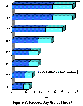
At any given time, each satellite simultaneously 'sees' all transmitters within an approximate 5000-kilometer- diameter 'footprint', or visibility circle. As the satellite proceeds in orbit, the visibility circle sweeps a 5000 kilometer swath around the Earth, covering both poles. Due to the Earth�s rotation, the swath shifts about the polar axis on each revolution. Because of the near-polar orbit, the number of daily passes over a transmitter increases with latitude. At the poles, each satellite passes approximately 14 times a day for a total of 28 (two satellites). At the equator there are 6 to 7 passes total.
The duration of transmitter visibility by the satellite (pass duration over the transmitter) is the 'window' during which the satellite can receive messages from the transmitter. It lasts between 8 and 15 minutes (10 minutes on average).
The Ground Segment
The three main ground stations (Wallops Island, Fairbanks, and Lannion) receive all messages recorded by the satellite during an orbital revolution, providing complete global coverage. Regional receiving stations receive transmitter data from the satellites in realtime whenever a satellite is within station visibility. The main ground stations also act as regional receiving stations. Regional receiving stations operate in Hawaii in the USA, Casey in Antarctica, and Darwin, Melbourne and Perth in Australia. More regional stations are planned.
The Global Processing Centers (GPCs) in Landover, MD, USA and Toulouse, France process all data received from the receiving stations. They archive the results and make them available to users online.
Regional Processing Centers (RPCs) provide users in a region with local access to results. For example, Japanese users can connect to the Argos RPC in Tokyo to access locations and sensor data from transmitters around the world.
Some RPCs, such as Melbourne, are connected to one or more regional receiving stations. This means they can process data received in real time from transmitters in visibility of the receiving stations. Each RPC is also connected to a GPC so that it can provide its users with global coverage, i.e. data received in other parts of the world.
Processing
The work of a GPC includes:
- quality control, including checking of message time-tagging, signal level, transmitter ID number, length of sensor data message, and the receive frequency for use in the Doppler location calculation.
- message classification in chronological order.
- location calculation (see below)
- sensor data processing
- data distribution via network or physical media
- archival of processed data
The data from each sensor on a given transmitter is processed separately. Users can therefore choose different processing options:
- A - which outputs the raw sensor data as numerical values,
- B - which converts raw sensor data into physical values using a different calibration curve for each sensor.
Improved Location Processing
The Argos location processing system has been improved to better classify locations and provide more locations in 'marginal' situations. Marginal situation refers to those passes during which very few messages are received. This can be due to low altitude of the pass, operation of the transmitter outside required specifications, or obstruction of the transmitter.
Argos locations are calculated by measuring the 'Doppler shift' on the platform transmissions. Relative to the transmit frequency (nominal frequency), the frequency measured by the satellite instrument is shifted upward as a satellite 'approaches' a PTT, and downward as the satellite moves away. Each time a message is received, the satellite instrument measures the receive frequency and timetags the message arrival. The nominal platform transmit frequency is estimated using the set of reception frequencies. The Doppler shift in frequency, along with other information, is used to calculate location of the transmitter.
To assign a class of location accuracy, the Argos processing centers need four messages from a transmitter during a pass. Optimally, the four messages should be spread approximately equally over the pass. There must be messages on each side of the point of inflection, i.e. where the satellite is closest to the transmitter in the middle of the pass. Knowing the position and movement of the satellite (see Orbitography), the transmit frequency, the receive frequencies (and times), and the altitude of the platform, two geometrically determined posi-tions can be calculated. The 'theoretical� Doppler curve for these two locations is compared with the measured Doppler curve to refine the position and provide quality control. Other plausibility checks employed to further enhance quality control include the stability of the transmitter, change in position since the last location, and anticipated velocity.
Location accuracy (Class designation) is determined using all the parameters in the calculation: spread of messages during the pass, pass duration, angular separation from ground track, least-squares residual of the Doppler measurement, and platform velocity.
As a result of the changes made, accuracies are now more reliable in all classes where location accuracy is provided. Standard locations (a minimum of 4 messages) comprise Classes 3, 2, 1, and 0. Class O locations have failed certain quality control checks; thus, there is no upper limit on their accuracy. However, these locations are available upon request and are usually used in the event of a transmitter problem. Classes A, B and Z have less than 4 messages and are available under a separate service, Auxiliary Location Processing.
Orbitography
Orbitography Processing is necessary to compute the orbit of the spacecraft. Knowing the location, direction of travel, and velocity of the spacecraft at any given time is a prerequisite to successful location of the PTTs. This is accomplished through a network of special transmitters. These are very stable and transmit a high-power signal. They are placed at geodedically surveyed locations around the world. When the system computes a location for one of these transmitters, the position of the spacecraft is adjusted to bring it into accordance with the known location of the transmitter. These adjustments are translated into a new set of parameters describing the size, shape, and orientation of the spacecraft�s orbit, known as the orbital elements.
This information is then used to create a table which describes the location, direction, and velocity of the spacecraft for the next twelve hours. The location processing system references this table and interpolates to obtain the precise values required. With added computing power available, this process is now run more frequently to enhance tracking of the satellite. This, in turn, improves location accuracy.
Argos plus GPS
Global Positioning System (GPS) positions are now processed along with Argos locations through the Argos system. Since GPS receivers continuously recalculate position fixes, higher temporal resolution is possible. For example, samples taken every 30 minutes can now be associated with a location. Results are integrated with Argos data, and GPS and Argos locations appear in the same format (a flag indicates whether Argos or GPS). Of course, use of a GPS receiver impacts on the platform's power requirements and costs.
Futures
NOAA-K (late-1996 launch), will be the first satellite to carry the next generation of Argos instru-ments (Argos II). This instrument comprises 8 data recovery units (as opposed to 4), operates at a wider bandwidth and carries a more sensitive receiver. These capabilities will enable a near quadrupling of capacity for the Argos system. Additional NOAA satellites are planned well into the next century and agreements are being established to carry Argos on other satellites as well.
Future considerations are to use the added bandwidth to establish 'channels' to meet particular User requirements. For example, a 'sensitive' channel for low power transmitters, and a 'high data rate' channel for large data volume applications.
In January of 1995, NASDA, the Japanese Space Agency, agreed to fly Argos on ADEOS II (launch in late 1999). Plans include a downlink to the platforms to enable remote control of PTTs in the field. This 'two-way' capability will enable transmitters and sensors to be switched on and off, recalibrated, etc. It markedly increases system functionality and provides Users added flexibility to manage their programs. Indeed, 'Downlink Messaging' represents yet another era in the evolution of the Argos system.