Name details
Bunger Hills
Bunger Hills (The name as it would appear in a gazetteer)
Bunger Hills (The name as it would appear on a map)
If this information is incorrect, please e-mail mapping@aad.gov.au
Feature type: Hill (2b)
Origin
This name originates from United States of America. It is part of the United States Gazetteer and the SCAR Composite Gazetteer of Antarctica.
Names that other countries have for this feature:
- Bunger Hills (Australia)
- Bunger Hills (Russia)
Narrative
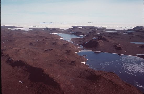
Group of moderately low, rounded coastal hills, overlain by morainic drift and notably ice free in the summer months, lying S of the Highjump Archipelago. The hills are marked by numerous meltwater ponds and are nearly bisected by E-W trending Algae Lake. Mapped from air photos taken by USN Operation HighJump, 1946-47, and named by the US-ACAN for Lt. Cdr. David E. Bunger, USN, plane commander of one of the three USN Operation HighJump aircraft which engaged in photographic missions along most of the coastal area between 14 E and 164 E. Bunger and members of his crew landed their airplane on an unfrozen lake here in February 1947.
Named For
Location
Images
©AAD, Copyright Commonwealth of Australia 1977
- Catalogue id
- 1800B4
- Caption
- Stream between Lake Figurnoje (L) and Transkiptii Inlet (R)
- Photographer
- Barker, Roger J
Map
Source
Comments
NoneApproval status
Display Scales
For example, selecting 'Aus_display_scale_20M' would only return names that would appear on a 1:20 million scale map.
| Aus_display_scale_20M: | No | Aus_display_scale_10M: | No | ||
| Aus_display_scale_5M: | No | Aus_display_scale_2M: | No | ||
| Aus_display_scale_1M: | No | Aus_display_scale_500k: | No | ||
| Aus_display_scale_250k: | No | Aus_display_scale_100k: | No | ||
| Aus_display_scale_50k: | No | Aus_display_scale_25k: | No | ||
| Aus_display_scale_10k: | No | Aus_display_scale_5k: | No | ||
| Aus_display_scale_1k: | No |
Related information
Biodiversity
View
fauna,
flora or
both
within 1.0 degree of this location
Place names
View
American or
international
place names within 1.0 degree of this location.