Name details
Bunger Hills
Bunger Hills (The name as it would appear in a gazetteer)
Bunger Hills (The name as it would appear on a map)
If this information is incorrect, please e-mail mapping@aad.gov.au
Feature type: Hill
Origin
This name originates from Australia. It is part of the Australian Antarctic Gazetteer and the SCAR Composite Gazetteer of Antarctica.
Names that other countries have for this feature:
- Bunger Hills (Russia)
- Bunger Hills (United States of America)
Narrative
An area of several hundred square km of ice-free rock at the western end of Knox Coast, Wilkes Land. The south-western extremity was seen from Watson Bluff on David Island at a distance of about 76 km by A L Kennedy, magnetician and second surveyor with the Western Base Party of the AAE (1911-14) was carrying out a survey on foot. Photographed by USN Operation Highjump (1946-47).
Named For
Named after Lieut. Cmdr. D E Bunger, USN, who made a landing on an un-frozen lake in February, 1947, whilst on a photo mission in a sea plane.
Location
Images
©AAD, Copyright Commonwealth of Australia 1977
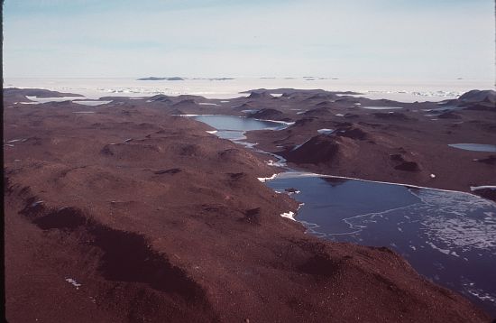
- Catalogue id
- 1800B4
- Caption
- Stream between Lake Figurnoje (L) and Transkiptii Inlet (R)
- Photographer
- Barker, Roger J
Map
Source
Comments
NoneApproval status
Display Scales
For example, selecting 'Aus_display_scale_20M' would only return names that would appear on a 1:20 million scale map.
| Aus_display_scale_20M: | Yes | Aus_display_scale_10M: | Yes | ||
| Aus_display_scale_5M: | No | Aus_display_scale_2M: | Yes | ||
| Aus_display_scale_1M: | Yes | Aus_display_scale_500k: | Yes | ||
| Aus_display_scale_250k: | Yes | Aus_display_scale_100k: | Yes | ||
| Aus_display_scale_50k: | No | Aus_display_scale_25k: | No | ||
| Aus_display_scale_10k: | No | Aus_display_scale_5k: | No | ||
| Aus_display_scale_1k: | No |
Related information
Biodiversity
View
fauna,
flora or
both
within 1.0 degree of this location
Place names
View
Australian or
international
place names within 1.0 degree of this location.