Name details
Highjump Archipelago
Highjump Archipelago (The name as it would appear in a gazetteer)
Highjump Archipelago (The name as it would appear on a map)
If this information is incorrect, please e-mail mapping@aad.gov.au
Feature type: Archipelago (5)
Origin
This name originates from United States of America. It is part of the United States Gazetteer and the SCAR Composite Gazetteer of Antarctica.
Names that other countries have for this feature:
- Highjump Archipelago (Australia)
- Highjump Archipelago (Russia)
Narrative
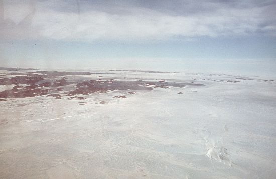
Group of rocky islands, rocks and ice rises about 50 mi long and from 5 to 15 mi wide, lying generally N of the Bunger Hills and extending from the Taylor Islands, close NW of Cape Hordern, to a prominent group of ice rises which terminate close W of Cape Elliott. Delineated from aerial photographs taken by USN Operation HighJump 1946-47 and so named by the US-ACAN. The codeword "highjump" was used for identifying the U.S. Navy Task Force 68, 1946-47. This task force was divided into three groups which completed photographic flights covering approximately 70 per cent of the coastal areas of Antarctica, excluding Antarctic Peninsula, as well as significant portions of the interior.
Named For
Location
Images
©AAD, Copyright Commonwealth of Australia 1984
- Catalogue id
- 1803B2
- Photographer
- Ledingham, Roderick B (Rod)
Map
Source
Comments
NoneApproval status
Display Scales
For example, selecting 'Aus_display_scale_20M' would only return names that would appear on a 1:20 million scale map.
| Aus_display_scale_20M: | No | Aus_display_scale_10M: | No | ||
| Aus_display_scale_5M: | No | Aus_display_scale_2M: | No | ||
| Aus_display_scale_1M: | Yes | Aus_display_scale_500k: | Yes | ||
| Aus_display_scale_250k: | Yes | Aus_display_scale_100k: | Yes | ||
| Aus_display_scale_50k: | Yes | Aus_display_scale_25k: | No | ||
| Aus_display_scale_10k: | No | Aus_display_scale_5k: | No | ||
| Aus_display_scale_1k: | No |
Related information
Biodiversity
View
fauna,
flora or
both
within 1.0 degree of this location
Place names
View
American or
international
place names within 1.0 degree of this location.