Rauer Islands
Rauer Islands (The name as it would appear in a gazetteer)
Rauer Islands (The name as it would appear on a map)
If this information is incorrect, please e-mail mapping@aad.gov.au
Place ID: 11898
Name ID: 130574
Feature type:
Island
(5)
Origin
This name originates from United States of America.
It is part of the
United States Gazetteer and the SCAR Composite Gazetteer of Antarctica.
Names that other countries have for this feature:
Narrative
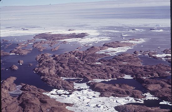
A group of rocky coastal islands which lie between Sorsdal Glacier Tongue and Ranvik Bay, in the SE part of Prydz Bay. Discovered and roughly charted in February 1935 by a Norwegian expedition under Capt. Klarius Mikkelsen. He named them Rauer, probably after the island lying in Oslofjorden opposite Tonsberg, Norway.
Named For
Location
Latitude:
68° 51' 00.0" S
-68.85000°
Unknown precision
Longitude:
77° 50' 00.0" E
77.83333°
Unknown precision
Altitude:
Not recorded
Unknown precision
Images
©AAD, Copyright Commonwealth of Australia 1974
- Catalogue id
- 240D5
- Photographer
- Williams, Richard (Dick)
Map
Source
Source Institution:
Unknown
Source Publisher:
Unknown
Remote sensing:
Not Applicable
Comments
None
Approval status
Date approved:
1-Jan-1947
Related information