Mount Menzies
Menzies, Mount (The name as it would appear in a gazetteer)
Mount Menzies (The name as it would appear on a map)
If this information is incorrect, please e-mail mapping@aad.gov.au
Place ID: 9441
Name ID: 1646
Feature type:
Mountain
Origin
This name originates from Australia.
It is part of the
Australian Antarctic Gazetteer and the SCAR Composite Gazetteer of Antarctica.
Names that other countries have for this feature:
Narrative
A prominent mountain, approximately 3228 m high, on the southern side of the Fisher Glacier in Mac.Robertson Land. First seen by Flying Officer J. Seaton from an ANARE Beaver aircraft in 1956. Mapped by ANARE southern seismic party 1957-58 led by K.B. Mather. Named after the Rt. Hon. R.G. Menzies (later Sir Robert Menzies), Prime Minister of Australia, 1939-41 and 1949-66.
Named For
Location
Latitude:
73° 27' 37.7" S
-73.46047°
Accurate to 10m
Longitude:
61° 53' 19.5" E
61.88875°
Accurate to 10m
Altitude:
3228 m
Accurate to 20m
Images
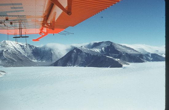
©AAD, Copyright Commonwealth of Australia 1960
- Catalogue id
- 4626A1
- Photographer
- Newton, Geoffrey (Geoff)
Map
Source
Location Method:
Surveyed
Source Name:
Geoscience Australia Survey Control Database
Source Institution:
Australian Antarctic Division
Source Publisher:
Geoscience Australia
Remote sensing:
Not Applicable
Comments
None
Approval status
Related information