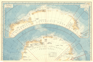
Map 1059: Antarctica. Sheet 2: Coastal Regions of the Australian Antarctic Territory
Map details
| Map Number | 1059 |
| Title | Antarctica. Sheet 2: Coastal Regions of the Australian Antarctic Territory |
| Edition | 1 |
| Scale | 1 : 5 250 000 |
| Publication date | 1939 |
| Publisher |
Department of National Development, Division of National Mapping (Australia)
|
| Spatial coverage |
( 40.0000° -55.0000°)
,
(165.0000° -55.0000°)
,
(165.0000° -73.0000°)
( 40.0000° -73.0000°) |
| Projection | Azimuthal Equidistant |
| Physical size | 76 x 101 cm |
| Notes |
Sheet 2 : Coastal regions of the Australian Antarctic Territory 1:5,250,000
see also Mapcat ref. 13393 Sheet 1 : Antarctica 1:7,500,000.
Compiled by E.P. Bayliss. See publication Handbook and Index to accompany a MAP OF ANTARCTIC by Bayliss and Cumpston. |
| Keywords | Australian Antarctic Territory , Coastal Regions , Historical , Balleny , AAE 1911-14 , BANZARE 1929-31 , British , New Zealand Antarctic Research Expedition , Australasian Antarctic Expedition , Bayliss Cumpston |
Downloads
This is a hard copy map that has been scanned. See information about obtaining copies of hard copy maps.
- National Library of Australia Bib ID 1859592 (External site)
- A LZW compressed TIFF
- A print file (PDF)
Map Lists
No maps lists available.
Additional Information
Preview