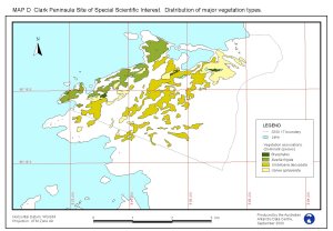
Map 11027: Distribution of major vegetation types on Clark Peninsula, Site of Special Site of Scientific Interest 17,(SSSI17) Windmill Islands, Wilkes Land.
Map details
| Map Number | 11027 |
| Title | Distribution of major vegetation types on Clark Peninsula, Site of Special Site of Scientific Interest 17,(SSSI17) Windmill Islands, Wilkes Land. |
| Edition | 1 (Out of Date) |
| Next Edition | [Next Edition : 2] |
| Scale | Not Entered |
| Publication date | September 2000 |
| Publisher |
Australian Antarctic Division (Australia)
|
| Spatial coverage |
(110.5000° -66.2330°)
,
(110.6600° -66.2330°)
,
(110.6600° -66.2830°)
(110.5000° -66.2830°) |
| Projection | Universal Transverse Mercator |
| Physical size | 21 x 29.7 cm A4 |
| Notes | This map is part of the "Plan of Management for the Site of Special Scientific Interest 17, Clark Peninsula, Wilkes Land", Map D. Published in SCAR Bulletin No 144, January 2002 |
| Keywords | Clark , Vegetation , Protected |
Downloads
This is a digital map available for downloading.
Map Lists
No maps lists available.
Additional Information
| Horizontal datum | WGS84 |
Preview