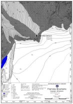
Map 11108: Locality map for the Mt Henderson refuge, Framnes Mountains
Map details
| Map Number | 11108 |
| Title | Locality map for the Mt Henderson refuge, Framnes Mountains |
| Edition | 1 |
| Scale | 1 : 5000 |
| Publication date | June 1999 |
| Publisher |
Australian Antarctic Division (Australia)
|
| Spatial coverage |
( 63.0333° -67.7000°)
,
( 63.0833° -67.7000°)
,
( 63.0833° -67.7333°)
( 63.0333° -67.7333°) |
| Projection | Universal Transverse Mercator |
| Physical size | - |
| Keywords | Topographic |
Downloads
This is a digital map available for downloading.
Map Lists
No maps lists available.
Additional Information
Preview