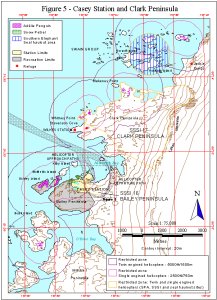
Map 11369: Figure 5 - Casey Station and Clark Peninsula Helicopter Operations
Map details
| Map Number | 11369 |
| Title | Figure 5 - Casey Station and Clark Peninsula Helicopter Operations |
| Edition | 1 |
| Scale | 1 : 75 000 |
| Publication date | June 1999 |
| Publisher |
Australian Antarctic Division (Australia)
|
| Spatial coverage |
(110.4700° -66.2200°)
,
(110.6700° -66.2200°)
,
(110.6700° -66.3300°)
(110.4700° -66.3300°) |
| Projection | Universal Transverse Mercator |
| Physical size | 29.7 x 21 cm |
| Notes | Used in the publication "Environmental Guidelines for Antarctic and Subantarctic Helicopter Operations". Edition 1 of the maps, November 1999 |
| Keywords | - |
Downloads
This is a digital map available for downloading.
Map Lists
No maps lists available.
Additional Information
Preview