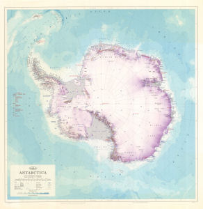
Map 1209: Antarctica
Map details
| Map Number | 1209 |
| Title | Antarctica |
| Edition | 5 (Out of Date) |
| Previous edition | [Previous edition : 4] |
| Next Edition | [Next Edition : 6] |
| Scale | 1 : 10 000 000 |
| Publication date | 1977 |
| Publisher |
Department of National Development, Division of National Mapping (Australia)
|
| Spatial coverage |
(-180.0000° -50.0000°)
,
(180.0000° -50.0000°)
,
(180.0000° -90.0000°)
(-180.0000° -90.0000°) |
| Projection | Polar Stereographic |
| Physical size | 75 x 76 cm |
| Notes | Without claims |
| Reference | NMP/76/213 |
| Keywords | Nmp/76/213 , Topographic |
Downloads
This is a hard copy map that has been scanned. See information about obtaining copies of hard copy maps.
- A LZW compressed TIFF
- National Library of Australia Bib ID 2334353 (External site)
- A print file (PDF)
- A LZW compressed TIFF (back)
- A print file (PDF) (back)
Map Lists
No maps lists available.
Additional Information
| Nomenclature | Australian Antarctic Gazetteer |
Preview