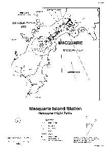
Map 12324: Macquarie Island Station Helicopter Flight Paths
Map details
| Map Number | 12324 |
| Title | Macquarie Island Station Helicopter Flight Paths |
| Edition | 1 |
| Scale | 1 : 5300 |
| Publication date | October 1996 |
| Publisher |
Australian Antarctic Division (Australia)
|
| Spatial coverage |
(158.9277° -54.4672°)
,
(158.9444° -54.4672°)
,
(158.9444° -54.5055°)
(158.9277° -54.5055°) |
| Projection | Not Given |
| Physical size | 29.7 x 21 cm A4 |
| Notes | The longitude graticule is slightly incorrect. See a more recent map. |
| Keywords | - |
Downloads
Map Lists
No maps lists available.
Additional Information
Preview