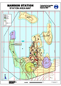
Map 12711: Mawson Station Area Map
Map details
| Map Number | 12711 |
| Title | Mawson Station Area Map |
| Edition | 2 |
| Previous edition | [Previous edition : 1] |
| Scale | 1 : 1500 |
| Publication date | September 2000 |
| Publisher |
Australian Antarctic Division (Australia)
|
| Spatial coverage |
( 62.8556° -67.5917°)
,
( 62.8833° -67.5917°)
,
( 62.8833° -67.6083°)
( 62.8556° -67.6083°) |
| Projection | Universal Transverse Mercator |
| Physical size | 117.5 x 84.5 cm |
| Notes |
This map is out of date. See Framnes Mountains / Holme Bay / Mawson map list for a current map of Mawson. |
| Keywords | Mawson Station Area , Entrance Island , Hump Island , Horseshoe Harbour , West Arm , East Arm , Topographic |
Downloads
This is a digital map available for downloading.
Map Lists
No maps lists available.
Additional Information
Preview