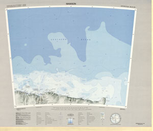
Map 128: SQ 41-42
Map details
| Map Number | 128 |
| Title | SQ 41-42 |
| Edition | 1 (Out of Date) |
| Previous edition | [Previous edition : Base Compilation] |
| Next Edition | [Next Edition : 2] |
| Scale | 1 : 1 000 000 |
| Publication date | 1978 |
| Publisher |
Department of National Development, Division of National Mapping (Australia)
|
| Spatial coverage |
( 60.0000° -64.0000°)
,
( 72.0000° -64.0000°)
,
( 72.0000° -68.0000°)
( 60.0000° -68.0000°) |
| Projection | Lambert Conformal Conic |
| Physical size | 54 x 87 cm |
| Reference |
SQ 41-42 Cat.No:S2 in 'ANARE Catalogue of Maps and Hydrographic Charts 1997' |
| Keywords | Mawson , Southern Ocean , Mawson Corridor , Taylor Rookery , Rookery Islands , Holme Bay , Framnes Mountains , Mawson Coast , Mac Robertson Land , Mac. Robertson Land , Auster Rookery , Storegg Bank , Gustav Bull Mountains , Scullin Monolith , Murray Monolith , Cape Rouse , Lars Christensen Coast , Bjerko Peninsula , Flutter Rookery , Fram Bank , SQ41-42 , SQ41/42 , Topographic |
Downloads
This is a hard copy map that has been scanned. See information about obtaining copies of hard copy maps.
- A print file (PDF)
- National Library of Australia Bib ID 2284906 (External site)
- A LZW compressed TIFF
Map Lists
No maps lists available.
Additional Information
| Nomenclature | Australian Antarctic Gazetteer |
Preview