Map 12814: Atlas of Parts of the Antarctic Coastal Lands / Prinsesse Ragnhild Land / Sheet 1
Map details
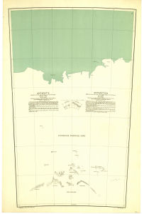
| Map Number | 12814 |
| Title | Atlas of Parts of the Antarctic Coastal Lands / Prinsesse Ragnhild Land / Sheet 1 |
| Edition | - |
| Scale | 1 : 500 000 |
| Publication date | 1946 |
| Publisher |
H.E. Hansen, Norsk Polarinstitutt, Oslo (Norway)
|
| Spatial coverage |
( 21.0000° -69.1667°)
,
( 27.0000° -69.1667°)
,
( 27.0000° -72.5000°)
( 21.0000° -72.5000°) |
| Projection | Not Given |
| Physical size | 81.5 x 53.5 cm |
| Reference | Atlas, Sheet 1 |
| Alternative title | Atlas over dele av Det Antarktiske Kystland / Prinsesse Ragnhild Land / Sheet 1 |
| Keywords | Atlas Over Dele Av Det Antarktiske Kystland , Atlas , Sheet 1 , Atlas Of Parts Of The Antarctic Coastal Lands , Prinsesse Ragnhild Land , Hansen Chart , Topographic |
Downloads
No downloads available.
This is a hard copy map. See information about obtaining copies of hard copy maps.
Map Lists
No maps lists available.
Additional Information
Preview