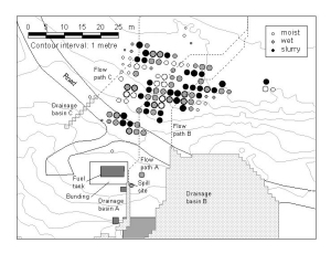
Map 12930: Oil spill site at Casey Station: predicted flow paths, predicted drainage basins, measured hydrocarbon concentrations (Fig 1)
Map details
| Map Number | 12930 |
| Title | Oil spill site at Casey Station: predicted flow paths, predicted drainage basins, measured hydrocarbon concentrations (Fig 1) |
| Edition | 1 |
| Scale | 1 : 700 |
| Publication date | April 2002 |
| Publisher |
Australian Antarctic Division (Australia)
|
| Spatial coverage |
(110.5242° -66.2816°)
,
(110.5263° -66.2816°)
,
(110.5263° -66.2822°)
(110.5242° -66.2822°) |
| Projection | Universal Transverse Mercator |
| Physical size | 9 x 12 cm |
| Notes | This figure was published in: M.J.Riddle, I.Snape, D.T.Smith and A.Z.Woinarski, 'Development and validation of a GIS-based dispersion model for oil spills in snow covered ground' in Proceedings of the 3rd International Conference Contaminants in Freezing Ground, Hobart 14-18 April 2002 |
| Keywords | Oil , Spill , Casey , Flow , Drainage , Hydrocarbon |
Downloads
This is a digital map available for downloading.
Map Lists
No maps lists available.
Additional Information
| Horizontal datum | WGS84 |
| Vertical datum | Mean sea level |
| Nomenclature | Australian Antarctic Names Gazetteer |
Preview