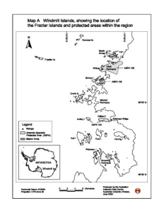
Map 12932: Windmill islands, showing the location of the Frazier Islands and protected areas within the region.
Map details
| Map Number | 12932 |
| Title | Windmill islands, showing the location of the Frazier Islands and protected areas within the region. |
| Edition | 1 (Out of Date) |
| Next Edition | [Next Edition : 2] |
| Scale | 1 : 250 000 |
| Publication date | June 2002 |
| Publisher |
Australian Antarctic Division (Australia)
|
| Spatial coverage |
(110.0000° -66.1667°)
,
(110.8333° -66.1667°)
,
(110.8333° -66.5333°)
(110.0000° -66.5333°) |
| Projection | Universal Transverse Mercator |
| Physical size | 19.1 x 14.4 cm |
| Notes | Map A prepared for Management Plan for the Frazier Islands 2002 |
| Keywords | - |
Downloads
This is a digital map available for downloading.
Map Lists
No maps lists available.
Additional Information
| Horizontal datum | WGS84 |
| Vertical datum | Mean Sea Level |
| Nomenclature | Australian Antarctic Gazetteer |
Preview