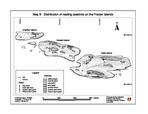
Map 12933: Distribution of nesting seabirds on the Frazier Islands
Map details
| Map Number | 12933 |
| Title | Distribution of nesting seabirds on the Frazier Islands |
| Edition | 1 (Out of Date) |
| Next Edition | [Next Edition : 2] |
| Scale | 1 : 12 700 |
| Publication date | June 2002 |
| Publisher |
Australian Antarctic Division (Australia)
|
| Spatial coverage |
(110.1333° -66.2208°)
,
(110.2000° -66.2208°)
,
(110.2000° -66.2361°)
(110.1333° -66.2361°) |
| Projection | Universal Transverse Mercator |
| Physical size | 14 x 18.6 cm |
| Notes | Map B prepared for Management Plan for the Frazier Islands 2002 |
| Keywords | Frazier Islands , Charlton Island , Dewart Island , Nelly Island |
Downloads
This is a digital map available for downloading.
Map Lists
No maps lists available.
Additional Information
| Horizontal datum | WGS84 |
| Vertical datum | Mean Sea Level |
| Nomenclature | Australian Antarctic Names Gazetteer |
Preview