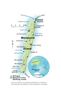
Map 12977: Macquarie Island
Map details
| Map Number | 12977 |
| Title | Macquarie Island |
| Edition | 1 |
| Scale | 1 : 410 000 |
| Publication date | 2003 |
| Publisher |
Australia
|
| Spatial coverage |
(158.7500° -54.0000°)
,
(159.0000° -54.0000°)
,
(159.0000° -55.0000°)
(158.7500° -55.0000°) |
| Projection | - |
| Physical size | 10 x 6 cm |
| Notes |
Produced by the Cartographic Division of Australian Geographic magazine and included in the article 'Mice on Macquarie Island' in the July - September 2003 edition, page 22. Users should seek permission from Australian Geographic Magazine if they wish to include this map in any publication. |
| Keywords | Macquarie Island , Hasselborough Bay , Halfmoon Bay , Bauer Bay , Davis Bay , Sandell Bay , Carrick Bay , Sandy Bay , North Head , Nuggets Point , Brothers Point , Green Gorge , Saddle Point , Hurd Point , Aurora Point , Cormorant Point |
Downloads
This is a digital map available for downloading.
Map Lists
This map belongs to the following lists. Use the link on the list to see all maps belonging to that list
Additional Information
Preview