Map 12980: PCMEGA program 2002-03
Map details
| Map Number | 12980 |
| Title | PCMEGA program 2002-03 |
| Edition | 1 |
| Scale | 1 : 6 451 600 |
| Publication date | 2002 |
| Publisher |
Australian Antarctic Division (Australia)
|
| Spatial coverage |
( 55.0000° -67.0000°)
,
( 80.0000° -67.0000°)
,
( 80.0000° -77.2500°)
( 55.0000° -77.2500°) |
| Projection | Mercator |
| Physical size | - |
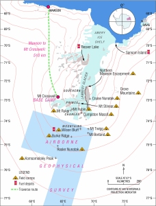
| Notes | Map published in Australian Antarctic Magazine no. 4 (Spring 2002). The area covered by an airborne geophysical survey is shown on the map. |
| Keywords | Pcmega Program , 2002-03 , Mt. Cresswell , Wilson Bluff , Burke Ridge , Komsomolskiy Peak , Rosler Nunatak , Mt. Ruker , Mt. Rubin , Cumpston Massif , Mt Stinear , Beaver Lake , Sansom Island , Lambert Glacier |
Downloads
This is a digital map available for downloading.
Map Lists
No maps lists available.
Additional Information
Preview