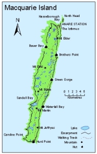
Map 13023: Macquarie Island Refuges
Map details
| Map Number | 13023 |
| Title | Macquarie Island Refuges |
| Edition | 1 |
| Scale | 1 : 450 000 |
| Publication date | September 2003 |
| Publisher |
Australian Antarctic Division (Australia)
|
| Spatial coverage |
(158.6667° -54.4667°)
,
(159.1667° -54.4667°)
,
(159.1667° -54.8333°)
(158.6667° -54.8333°) |
| Projection | Universal Transverse Mercator |
| Physical size | 8.5 x 5.3 cm |
| Notes | This map was produced for the Macquarie Island Emergency and Contingency Manual |
| Keywords | Macquarie Island , Refuges , Bauer Bay , Caroline Point , Hurd Point , Mt Jeffryes , Mt Martin , Waterfall Bay , Green Gorge , Brothers Point , Mt Elder , Hasselborough Bay , North Head , Mt Blake , Mt Eitel |
Downloads
This is a digital map available for downloading.
Map Lists
This map belongs to the following lists. Use the link on the list to see all maps belonging to that list
Additional Information
| Horizontal datum | WGS84 |
| Nomenclature | Names have been approved by the Nomenclature Board of Tasmania |
Preview