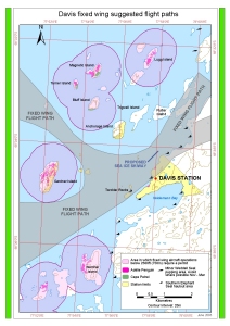
Map 13026: Davis fixed wing suggested flight paths
Map details
| Map Number | 13026 |
| Title | Davis fixed wing suggested flight paths |
| Edition | 1 (Out of Date) |
| Next Edition | [Next Edition : 2] |
| Scale | 1 : 40 000 |
| Publication date | June 2003 |
| Publisher |
Australian Antarctic Division (Australia)
|
| Spatial coverage |
( 77.8500° -68.5306°)
,
( 78.5000° -68.5306°)
,
( 78.5000° -68.6111°)
( 77.8500° -68.6111°) |
| Projection | Universal Transverse Mercator |
| Physical size | - |
| Keywords | Davis Fixed Wing Flight Paths , Sea Ice Skiway , Magnetic Island , Turner Island , Bluff Island , Anchorage Island , Trigwell Island , Lugg Island , Flutter Island , Torckler Rocks , Gardner Island , Warriner Island , Heidemann Bay |
Downloads
This is a digital map available for downloading.
Map Lists
No maps lists available.
Additional Information
| Horizontal datum | WGS84 |
| Vertical datum | Mean Sea Level |
| Nomenclature | Australian Antarctic Gazetteer |
Preview