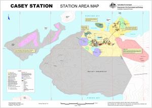
Map 13049: Casey Station Area Map
Map details
| Map Number | 13049 |
| Title | Casey Station Area Map |
| Edition | 8 |
| Previous edition | [Previous edition : 7] |
| Scale | 1 : 3200 |
| Publication date | December 2003 |
| Publisher |
Australian Antarctic Division (Australia)
|
| Spatial coverage |
(110.4666° -66.2667°)
,
(110.5666° -66.2667°)
,
(110.5666° -66.3000°)
(110.4666° -66.3000°) |
| Projection | Universal Transverse Mercator |
| Physical size | 84 x 119 cm |
| Notes |
This map is out of date. See Windmill Islands / Casey map list for a current map of Casey. |
| Keywords | Casey Station , Shirley Island , Phelps Island , Mcmullin Island , Newcomb Bay , Old Casey , Reeve Hill , Budnick Hill , Brown Bay , Thala Valley , ASPA 135 , Bailey Peninsula |
Downloads
This is a digital map available for downloading.
Map Lists
No maps lists available.
Additional Information
| Horizontal datum | WGS84 |
| Vertical datum | Mean Sea Level |
| Nomenclature | Australian Antarctic Names Gazetteer |
Preview