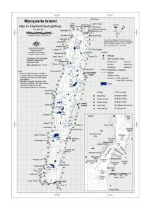
Map 13118: Macquarie Island: Map for Elephant Seal sightings
Map details
| Map Number | 13118 |
| Title | Macquarie Island: Map for Elephant Seal sightings |
| Edition | 1 |
| Scale | 1 : 143 300 |
| Publication date | December 2004 |
| Publisher |
Australian Antarctic Division (Australia)
|
| Spatial coverage |
(158.6667° -54.4167°)
,
(159.1667° -54.4167°)
,
(159.1667° -54.8333°)
(158.6667° -54.8333°) |
| Projection | Universal Transverse Mercator |
| Physical size | 29.7 x 21 cm A4 |
| Reference | ND-236XA (same map simplified) |
| Keywords | Macquarie Island , Elephant Seal Sightings , Grid |
Downloads
This is a digital map available for downloading.
Map Lists
This map belongs to the following lists. Use the link on the list to see all maps belonging to that list
Additional Information
| Horizontal datum | WGS84 |
| Vertical datum | Mean sea level |
| Magnetic variation | Magnetic North is 31 degrees east of True North. |
| Nomenclature | The following names are unofficial: "Fossil Cove", "Radio Beach", "Razorback East", "Ball Park", "Razorback West", "Magnetic Beach", "Camp Beach". The other names have been approved by the Nomenclature Board of Tasmania. |
Preview