Map 13119: Cape Denison : Mawson's huts historic site
Map details
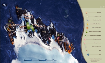
| Map Number | 13119 |
| Title | Cape Denison : Mawson's huts historic site |
| Edition | 1 |
| Scale | 1 : 8420 |
| Publication date | 2003 |
| Publisher |
Australian Antarctic Division (Australia)
|
| Spatial coverage |
(142.6500° -67.0028°)
,
(142.6944° -67.0028°)
,
(142.6944° -67.0161°)
(142.6500° -67.0161°) |
| Projection | - |
| Physical size | 21 x 34.5 cm |
| Notes | IKONOS satellite image captured 31 January 2001. Satellite image digitally enhanced by Vanessa Tucker. PDF (2.6 Mb) is available on request to the Australian Antarctic Data Centre. This map is included in the publication "Mawson's huts historic site, Cape Denison, Commonwealth Bay : a place of international significance" published by the Australian Antarctic Division, 2003. |
| Keywords | Cape Denison , Commonwealth Bay , Mawson's Huts , Azimuth Hill , Penguin Knob , Beryl Hill , Petrel Hill , Satellite Imagery |
Downloads
Map Lists
This map belongs to the following lists. Use the link on the list to see all maps belonging to that list
Additional Information
| Nomenclature | Australian Antarctic Names Gazetteer |
Preview