Map 13130: Larsemann Hills : environmental management map
Map details
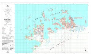
| Map Number | 13130 |
| Title | Larsemann Hills : environmental management map |
| Edition | 1 |
| Scale | 1 : 25 000 |
| Publication date | April 2005 |
| Publisher |
Australian Antarctic Division (Australia)
|
| Spatial coverage |
( 75.8944° -69.3333°)
,
( 76.5333° -69.3333°)
,
( 76.5333° -69.4833°)
( 75.8944° -69.4833°) |
| Projection | Universal Transverse Mercator |
| Physical size | 72.5 x 123 cm |
| Notes | The map includes the ASMA boundary and management zones proposed in the Draft Antarctic Specially Managed Area Management Plan for the Larsemann Hills, East Antarctica. |
| Keywords | Larsemann Hills , Stornes Peninsula , Broknes Peninsula , Thala Fjord , Quilty Bay , Dalkoy Bay , Dalk Glacier , Johnston Fjord , Barry Jones Bay , Webster Bay , Clemence Fjord , Nella Fjord |
Downloads
This is a digital map available for downloading.
Map Lists
This map belongs to the following lists. Use the link on the list to see all maps belonging to that list
Additional Information
| Horizontal datum | WGS84 |
| Vertical datum | Mean sea level |
| Magnetic variation | Magnetic north is 78 deg. west of True north |
| Nomenclature | Australian Antarctic Names Gazetteer |
Preview