Map 13135: Broknes Peninsula, Larsemann Hills : environmental management map
Map details
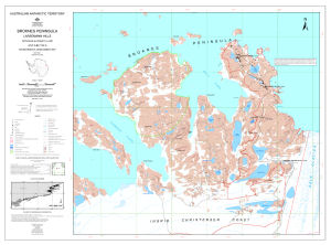
| Map Number | 13135 |
| Title | Broknes Peninsula, Larsemann Hills : environmental management map |
| Edition | 1 |
| Scale | 1 : 10 000 |
| Publication date | April 2005 |
| Publisher | - |
| Spatial coverage |
( 76.2556° -69.3611°)
,
( 76.4319° -69.3611°)
,
( 76.4319° -69.4194°)
( 76.2556° -69.4194°) |
| Projection | Universal Transverse Mercator |
| Physical size | 68.5 x 93 cm |
| Notes | The map includes the ASMA boundary and management zones proposed in the Draft Antarctic Specially Managed Area Mangagement Plan for the Larsemann Hills, East Antarctica. |
| Keywords | Broknes Peninsula , Larsemann Hills , Nella Fjord , Clemence Fjord , Fisher Island , Boulder Lake , Progress Lake , Lake Scandrett , Discussion Lake , Lake Reid , Lake Sibthorpe , Lake Jacques , Stepped Lake , Dalk Glacier , Lied Promontory , Sorensen Bluff , Stinear Peninsula , Lake Bruehwiler , Topographic |
Downloads
This is a digital map available for downloading.
Map Lists
This map belongs to the following lists. Use the link on the list to see all maps belonging to that list
Additional Information
| Horizontal datum | WGS84 |
| Vertical datum | Mean sea level |
| Magnetic variation | Magnetic north is 78 deg. west of True north |
| Nomenclature | Australian Antarctic Gazetteer |
Preview