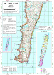
Map 13146: Macquarie Island Helicopter Exclusion Zone (Southern Sheet)
Map details
| Map Number | 13146 |
| Title | Macquarie Island Helicopter Exclusion Zone (Southern Sheet) |
| Edition | 1 |
| Scale | 1 : 50 000 |
| Publication date | January 2005 |
| Publisher |
Australian Antarctic Division (Australia)
|
| Spatial coverage |
(158.7000° -54.5833°)
,
(158.9500° -54.5833°)
,
(158.9500° -54.8333°)
(158.7000° -54.8333°) |
| Projection | Universal Transverse Mercator |
| Physical size | 42 x 29.7 cm A3 |
| Notes | The helicopter exclusion zones were defined by the Parks and Wildlife Service, Tasmania. Inset of Exclusion zone for all of Macquarie Island Inset of VHF reception for all Macquarie Island |
| Keywords | Macquarie Island , Helicopter Exclusion Zone , Vhf Reception |
Downloads
This is a digital map available for downloading.
Map Lists
No maps lists available.
Additional Information
| Horizontal datum | WGS84 |
| Vertical datum | Mean Sea Level |
| Magnetic variation | Magnetic North is 31 degrees east of True North |
| Nomenclature | Track names are unofficial. Other names have been approved by the Nomenclature Board of Tasmania. |
Preview