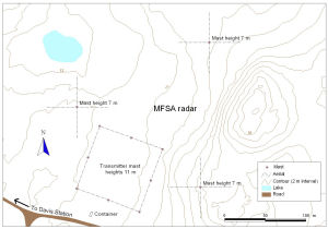
Map 13204: MFSA radar at Davis Station, Antarctica
Map details
| Map Number | 13204 |
| Title | MFSA radar at Davis Station, Antarctica |
| Edition | 1 |
| Scale | 1 : 1400 |
| Publication date | November 2005 |
| Publisher |
Australian Antarctic Division (Australia)
|
| Spatial coverage |
( 77.9764° -68.5722°)
,
( 77.9889° -68.5722°)
,
( 77.9889° -68.5756°)
( 77.9764° -68.5756°) |
| Projection | Universal Transverse Mercator |
| Physical size | - |
| Keywords | Mfsa Radar , Transmitter Mast |
Downloads
Map Lists
This map belongs to the following lists. Use the link on the list to see all maps belonging to that list
Additional Information
Preview