Map 13278: Adelie penguin presence in the Robinson Group
Map details
| Map Number | 13278 |
| Title | Adelie penguin presence in the Robinson Group |
| Edition | 1 |
| Scale | 1 : 300 000 |
| Publication date | May 2006 |
| Publisher |
Australian Antarctic Division (Australia)
|
| Spatial coverage |
( 63.2333° -67.3333°)
,
( 64.1167° -67.3333°)
,
( 64.1167° -67.5667°)
( 63.2333° -67.5667°) |
| Projection | Universal Transverse Mercator |
| Physical size | 21 x 29.7 cm A4 |
| Notes |
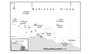
Produced by the Australian Antarctic Data Centre for inclusion in: Low, M., Meyer, L. and Southwell, C. (2007), Number and distribution of Adélie penguin (Pygoscelis adeliae) breeding sites in the Robinson Group of islands, Mac.Robertson Land coast, East Antarctica., Polar Record, 43, 225-229, doi:doi:10.1017/S0032247407006365 The islands displayed in black indicate the presence of Adélie penguin colonies, as surveyed during the 2005/6 summer; the grey polygons represent surveyed islands where no penguins were found. The large area of grey at the bottom of the map is continental ice. Inset: Map showing relationship of Robinson Group to Mawson Station and Amery Ice Shelf |
| Keywords | Robinson Group , Auster Islands , Douglas Islands , Child Rocks , Andersen Island , Thorgaut Island , Kirton Island , Macklin Island , Macey Islands , Austskjera , Penguin Colonies |
Downloads
This is a digital map available for downloading.
Map Lists
This map belongs to the following lists. Use the link on the list to see all maps belonging to that list
Additional Information
| Nomenclature | Australian Antarctic Names Gazetteer |
Preview