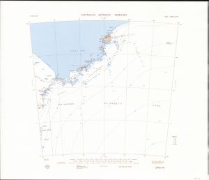
Map 133: SR 43-44
Map details
| Map Number | 133 |
| Title | SR 43-44 |
| Edition | 2 (Out of Date) |
| Previous edition | [Previous edition : 1] |
| Next Edition | [Next Edition : 4] |
| Scale | 1 : 1 000 000 |
| Publication date | 1987 |
| Publisher |
Department of National Development, Division of National Mapping (Australia)
|
| Spatial coverage |
( 72.0000° -68.0000°)
,
( 84.0000° -68.0000°)
,
( 84.0000° -72.0000°)
( 72.0000° -72.0000°) |
| Projection | Lambert Conformal Conic |
| Physical size | 58 x 63 cm |
| Notes | Compilation Map. |
| Reference |
SR 43-44 (S14) NMP/86/007.52 |
| Keywords | Topographic , Princes Elizabeth Land , Ingrid Christensen Coast , Prydz Bay , Vestfold , Davis , Amery Ice Shelf , SR43-44 |
Downloads
This is a hard copy map that has been scanned. See information about obtaining copies of hard copy maps.
- National Library of Australia Bib ID 2679909 (External site)
- National Library of Australia Bib ID 4465575 (External site)
- A print file (PDF)
- A LZW compressed TIFF
Map Lists
No maps lists available.
Additional Information
Preview