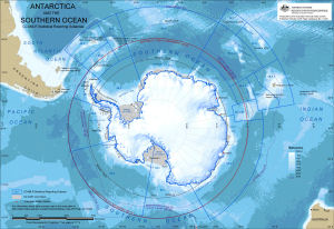
Map 13325: Antarctica and the Southern Ocean : CCAMLR statistical reporting subareas [A3]
Map details
| Map Number | 13325 |
| Title | Antarctica and the Southern Ocean : CCAMLR statistical reporting subareas [A3] |
| Edition | 1 |
| Scale | 1 : 33 400 000 |
| Publication date | October 2006 |
| Publisher | - |
| Spatial coverage |
(-180.0000° -30.0000°)
,
(180.0000° -30.0000°)
,
(180.0000° -90.0000°)
(-180.0000° -90.0000°) |
| Projection | Polar Stereographic |
| Physical size | 29.7 x 42 cm A3 |
| Notes |
Information about data used in this map can be obtained by searching using the following Dataset ids: Antarctic Polar Front: Dataset 33 Maximum extent of sea ice: Dataset 181 (Qinfo 523) Bathymetry: Dataset 186 (Qinfos 534, 535, 537 to 540) Antarctica: Dataset 134 CCAMLR Statistical Reporting Subareas: Dataset 206 (Qinfo 409) Map number 13111 is a similar map which also shows territorial claims. Statistical Reporting Subarea 58.4.4 has been divided into two subareas since this map was published. See Map number 13580 for current subarea boundaries as at March 2009. |
| Keywords | CCAMLR Statistical Reporting Subarea , Antarctic Treaty Boundary , Antarctic Polar Front , Sea Ice Extent |
Downloads
This is a digital map available for downloading.
Map Lists
No maps lists available.
Additional Information
Preview