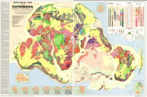
Map 13401: Geological map of sectors of Gondwana reconstructed to their disposition 150 Ma
Map details
| Map Number | 13401 |
| Title | Geological map of sectors of Gondwana reconstructed to their disposition 150 Ma |
| Edition | 1 |
| Scale | 1 : 10 000 000 |
| Publication date | 1988 |
| Publisher |
The American Association of Petroleum Geologists (United States of America)
|
| Spatial coverage |
(-180.0000° 40.0000°)
,
(180.0000° 40.0000°)
,
(180.0000° -90.0000°)
(-180.0000° -90.0000°) |
| Projection | Lambert Azimuthal Equal Area |
| Physical size | 113 x 170 cm |
| Notes |
Based on Geological world atlas series (C.G.M.W., Paris) and the Tectonic map of Antarctica (N.I.I.G.A., Leningrad 1980). Published by the American Association of Petroleum Geologists and the Bernard Price Institute of Geophysical Research, University of Witwatersrand. Compiled by Maarten de Wit, Margaret Jeffery, Hugh Bergh and Louis Nicolaysen. Includes references. Insets show Gondwana dispersion; Microplates of West Antarctica; Apparent polar wander path for the southern continents relative to India; and Global distribution of Gondwana in Pangean times. |
| Keywords | Gondwana Dispersion , Microplates Of West Antarctica , Pangean , Geology |
Downloads
No downloads available.
This is a hard copy map. See information about obtaining copies of hard copy maps.
Map Lists
No maps lists available.
Additional Information
Preview