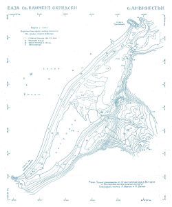
Map 13424: St. Kliment Ohridski Base, Livingston Island
Map details
| Map Number | 13424 |
| Title | St. Kliment Ohridski Base, Livingston Island |
| Edition | 1 |
| Scale | 1 : 1000 |
| Publication date | 1996 |
| Publisher |
Antarctic Place-names Commission of Bulgaria (Bulgaria)
|
| Spatial coverage |
( -60.3711° -62.6386°)
,
( -60.3628° -62.6386°)
,
( -60.3628° -62.6433°)
( -60.3711° -62.6433°) |
| Projection | - |
| Physical size | 57 x 47.5 cm |
| Notes | The map is in Bulgarian language |
| Reference | http://commons.wikimedia.org/wiki/Image:Ohridski-Map.jpg |
| Keywords | Saint Kliment Ohridski Base , Livingston Island , Survey Marks , Topographic |
Downloads
This is a hard copy map that has been scanned. See information about obtaining copies of hard copy maps.
Map Lists
No maps lists available.
Additional Information
Preview