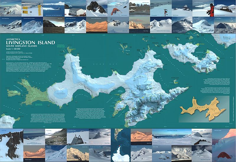
Map 13425: Antarctica: Livingston Island, South Shetland Islands
Map details
| Map Number | 13425 |
| Title | Antarctica: Livingston Island, South Shetland Islands |
| Edition | 1 |
| Scale | 1 : 100 000 |
| Publication date | August 2005 |
| Publisher |
Antarctic Place-names Commission of Bulgaria (Bulgaria)
|
| Spatial coverage |
( -61.3589° -62.4072°)
,
( -59.4247° -62.4072°)
,
( -59.4247° -62.7633°)
( -61.3589° -62.7633°) |
| Projection | Lambert Conformal Conic |
| Physical size | 67 x 99 cm |
| Notes | The map features also photographic illustrations, and textual information on the history, geography, and scientific facilities on Livingston Island and Greenwich Island. Circulation 1802. |
| Reference | http://commons.wikimedia.org/wiki/Image:Livingston-Greenwich-map.jpg |
| Alternative title | Antarctica: Livingston and Greenwich Islands, South Shetland Islands (from English Strait to Morton Strait, with illustrations and ice-cover distribution) |
| Keywords | Livingston Island , South Shetland Islands , Byers Peninsula , Rugged Island , Cape Shirreff , San Telmo Island , Ioannes Paules Ii Peninsula , Hurd Ice Cap , Huron Glacier , Greenwich Island , Varna Peninsula , Huntress Glacier , Rotch Dome , Hero Bay , Desolation Island , Topographic |
Downloads
Map Lists
No maps lists available.
Additional Information
| Horizontal datum | WGS84 |
| Vertical datum | MSL (Mean Sea Level) |
| Nomenclature | SCAR Composite Gazetteer |
Preview
