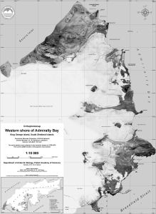
Map 13462: Western shore of Admiralty Bay, King George Island : orthophoto map
Map details
| Map Number | 13462 |
| Title | Western shore of Admiralty Bay, King George Island : orthophoto map |
| Edition | 1 |
| Scale | 1 : 10 000 |
| Publication date | November 2007 |
| Publisher |
Department of Antarctic Biology, Polish Academy of Sciences (Poland)
|
| Spatial coverage |
( -58.5472° -62.0972°)
,
( -58.4167° -62.0972°)
,
( -58.4167° -62.1167°)
( -58.5472° -62.1167°) |
| Projection | Transverse Mercator |
| Physical size | 94 x 69 cm |
| Notes |
Compiled by Rafal Pudelko. Inset: King George Island showing location of scientific stations. The aerial photos were collected in the summer season of 1978/1979. The current 2007 border of the glaciers is marked. |
| Keywords | Warszawa Icefield , Warsaw Icefield , Escura Inlet , Sphinx Glacier , Czajkowski Needle , Zamek , Tower Glacier , Windy Glacier , Baszta , Demay , Patelnia , Satellite Imagery |
Downloads
No downloads available.
This is a hard copy map. See information about obtaining copies of hard copy maps.
Map Lists
No maps lists available.
Additional Information
| Horizontal datum | WGS84 |
Preview