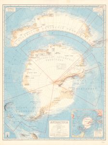
Map 13471: Antarctica
Map details
| Map Number | 13471 |
| Title | Antarctica |
| Edition | 1 (Out of Date) |
| Next Edition | [Next Edition : 2 ] |
| Scale | 1 : 10 000 000 |
| Publication date | 1939 |
| Publisher |
Department of National Development, Division of National Mapping (Australia)
|
| Spatial coverage |
(-180.0000° -45.0000°)
,
(180.0000° -45.0000°)
,
(180.0000° -90.0000°)
(-180.0000° -90.0000°) |
| Projection | Azimuthal Equidistant |
| Physical size | 101 x 76 cm |
| Notes |
Inset: Coastal regions of the Australian Antarctic Territory (1:7,000,000). Inset: The Antarctic continent in relation to the principal land masses in the southern hemisphere (1:60,000,000). Includes Lincoln Ellsworth's Trans-Antarctic flight line of 1935. Compiled by E.P. Bayliss. See also Mapcat 13393 and Mapcat 1059 compiled by E.P. Bayliss on 2 sheets, respectively "Antarctica" [1:7,500,000] and "Coastal regions of the Australian Antarctic Territory" [1:5,250,000] There is also a handbook, Handbook and Index by E. P. Bayliss and J. S. Cumpston, to accompany the map. It is a comprehensive statement, showing the sources of the material used and the determinations accepted when compiling the map in tabulated form. The handbook also contains additional features of interest, such as an outline of exploration in Antarctica at that time, and an account of the research carried out by the Discovery Committee. |
| Keywords | Bayliss Cumpston , Coastal Regions , Australian Antarctic Territory , AAE 1911-14 , Banzare 1929-31 , British , Australian And New Zealand Antarctic Research Expedition , Australasian Antarctic Expedition , Ellsworth Trans-Antarctic Flight , South Magnetic Polar Area 1939 , Historical , Handbook And Index , E. P. Bayliss And J. S. Cumpston , Map Of Antarctica , Historical , Catalogue / Index |
Downloads
This is a hard copy map that has been scanned. See information about obtaining copies of hard copy maps.
- Download a 300dpi image from the National Library of Australia
- A LZW compressed TIFF (tear right side)
- A print file (PDF) (several tears)
- A LZW compressed TIFF (several tears)
- A print file (PDF) (tear right side)
Map Lists
No maps lists available.
Additional Information
Preview