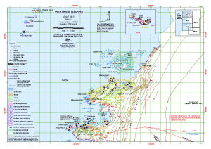
Map 13494: Windmill Islands : Map 1 of 5
Map details
| Map Number | 13494 |
| Title | Windmill Islands : Map 1 of 5 |
| Edition | 3 (Out of Date) |
| Previous edition | [Previous edition : 2] |
| Next Edition | [Next Edition : 4] |
| Scale | 1 : 50 000 |
| Publication date | September 2008 |
| Publisher |
Australian Antarctic Division (Australia)
|
| Spatial coverage |
(110.3681° -66.1739°)
,
(110.6723° -66.1739°)
,
(110.6723° -66.2972°)
(110.3681° -66.2972°) |
| Projection | Universal Transverse Mercator |
| Physical size | 29.7 x 42 cm A3 |
| Keywords | Windmill Islands , Clark Peninsula , Bailey Peninsula , Swain Group , ASPA 135 , ASPA 136 , ASPA 160 , Frazier Islands , Honkala Island , Burnett Island , Shirley Island , Donovan Islands , Jack's Donga , Wilkes Hilton , Aircraft Wreck Nov 1961 , Berkley Island , Survey Marks , Topographic |
Downloads
This is a digital map available for downloading.
Map Lists
No maps lists available.
Additional Information
| Horizontal datum | WGS 84 |
| Vertical datum | Mean sea level |
| Magnetic variation | Magnetic North is 99 degrees west of True North |
| Nomenclature | Australian Antarctic Names Gazetteer |
Preview