Map 13553: Sydishavet : fra 50 deg. til 73 deg. S.BR. og fra 110 deg.0. til 160 deg. V.LGD.
Map details
| Map Number | 13553 |
| Title | Sydishavet : fra 50 deg. til 73 deg. S.BR. og fra 110 deg.0. til 160 deg. V.LGD. |
| Edition | 1 |
| Scale | 1 : 5 000 000 |
| Publication date | 1936 |
| Publisher |
Norwegian Whalers Assurance Association (Norway)
|
| Spatial coverage |
(110.0000° -50.0000°)
,
(160.0000° -50.0000°)
,
(160.0000° -73.0000°)
(110.0000° -73.0000°) |
| Projection | Not Given |
| Physical size | 65.5 x 107 cm |
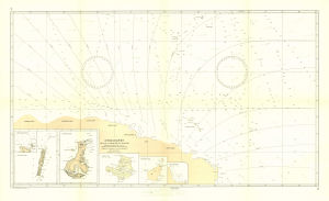
| Notes |
Map published in the "Atlas over Antarktis og Sydishavet utgitt av Hvalfangernes Assuranceforening i anledning av foreningens 25-Are jubileum" edited by Captain H.E. Hansen Insets include Macquarie Island, Auckland Islands, Campbell Island, Antipodes Islands |
| Alternative title | Southern Ocean : from 50 deg. to 73 deg.south latitude and from 110 deg. east to 160 deg. west longitude |
| Keywords | Hansen , Historical |
Downloads
Map Lists
No maps lists available.
Additional Information
Preview