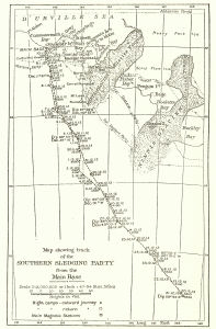
Map 13579: Map showing track of the Southern sledging party from the main base [Commonwealth Bay]
Map details
| Map Number | 13579 |
| Title | Map showing track of the Southern sledging party from the main base [Commonwealth Bay] |
| Edition | 1 |
| Scale | 1 : 3 000 000 |
| Publication date | 1942 |
| Publisher |
Government Printing Office (Australia)
|
| Spatial coverage |
(141.0000° -66.4167°)
,
(149.0000° -66.4167°)
,
(149.0000° -70.9667°)
(141.0000° -70.9667°) |
| Projection | Not Given |
| Physical size | 20.5 x 13 cm |
| Notes |
Published in Australasian Antarctic Expedition 1911-14 Scientific Reports. Series A: Volume 1, Geographical narrative and cartography by Douglas Mawson. Figure 14, Page 201. Sydney: Government Printing Office, 1942. [Held in Special Collection, Australian Antarctic Division Library] Georeferenced |
| Alternative title | Route map of the Southern sledge party |
| Keywords | Southern Sledging Party , Mertz Glacier , Ninnis Glacier , Cathedral Grotto , Buckley , Bay , Doolette Bay , Fisher Bay , Buchanan Bay , Stillwell Bay , Mt Hunt , Mt Murchison , Aurora Peak , historical , Australasian Antarctic Expedition , AAE |
Downloads
This is a hard copy map that has been scanned. See information about obtaining copies of hard copy maps.
Map Lists
This map belongs to the following lists. Use the link on the list to see all maps belonging to that list
Additional Information
Preview