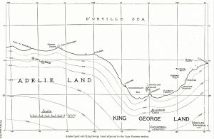
Map 13612: Adelie Land and King George Land adjacent to the Cape Denison station
Map details
| Map Number | 13612 |
| Title | Adelie Land and King George Land adjacent to the Cape Denison station |
| Edition | 1 |
| Scale | 1 : 355 000 |
| Publication date | 1942 |
| Publisher |
Government Printing Office (Australia)
|
| Spatial coverage |
(141.0000° -66.5833°)
,
(143.3667° -66.5833°)
,
(143.3667° -67.1667°)
(141.0000° -67.1667°) |
| Projection | Not Given |
| Physical size | 14 x 22.5 cm |
| Notes | Published in the "Australasian Antarctic Expedition 1911-14, Scientific Reports. Series A: Volume 1, Part 2: Cartography" by Douglas Mawson. Map plate VI, p.314 Sydney: Government Printing Office, 1942. [Held in special Collection, Australian Antarctic Division Library] |
| Keywords | Aladdin's Cave , Cathedral Grotto , Mount Lacroix , Mackellar Islets , Curzon Islets , Cape Discovery , Cape De Margerie , Point Alden , Laseron Islets , Hannam Islets , Fletcher Islet , Blair Islets , historical , Australasian Antarctic Expedition , AAE |
Downloads
This is a hard copy map that has been scanned. See information about obtaining copies of hard copy maps.
Map Lists
This map belongs to the following lists. Use the link on the list to see all maps belonging to that list
Additional Information
Preview