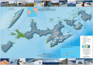
Map 13672: Antarctica: Livingston Island and Greenwich, Robert, Snow and Smith Islands
Map details
| Map Number | 13672 |
| Title | Antarctica: Livingston Island and Greenwich, Robert, Snow and Smith Islands |
| Edition | 1 (Out of Date) |
| Next Edition | [Next Edition : 2] |
| Scale | 1 : 120 000 |
| Publication date | May 2009 |
| Publisher |
Manfred Wörner Foundation (Bulgaria)
|
| Spatial coverage |
( -62.9167° -62.2833°)
,
( -59.2833° -62.2833°)
,
( -59.2833° -63.1667°)
( -62.9167° -63.1667°) |
| Projection | Universal Transverse Mercator |
| Physical size | 68.4 x 97.6 cm |
| Notes | Author Lyubomir Ivanov. Map made by the Military Geographic Service of the Bulgarian Army, the Antarctic Place-Names Commission of Bulgaria, and the Institute of Mathematics and Informatics in Sofia. The map is promoted by the Ministry of Education, Youth and Science as a teaching aid for geography and economy, and for nature sciences and ecology in the Bulgarian schools in the country and abroad. Free copies of the map have been donated by the publisher to all Bulgarian schools. Circulation 4000. |
| Reference | ISBN:9789549203240 |
| Keywords | Aitcho Islands , Half Moon Island , Rugged Island , Desolation Island , Hannah Point , Byers Peninsula , Ioannes Paules Ii Peninsula , Cape Shirreff , San Telmo Island , Hurd Peninsula , Bulgarian Beach , Varna Peninsula , Vidin Heights , Tangra Mountains , Mount Friesland , Bowles Ridge , Burgas Peninsula , Rozhen Peninsula , Dryanovo Heights , Breznik Heights , Imeon Range , Mount Foster , Alfatar Peninsula , Drake Passage , Bransfield Strait , Boyd Strait , Morton Strait , Mcfarlane Strait , English Strait , Hero Bay , Moon Bay , South Bay , Discovery Bay , St. Kliment Ohridski Base , Ohridski Base , Camp Academia , Juan Carlos I Base , Shirreff Base , Arturo Prat Base , Pedro Vicente Maldonado Base , CÁMara Base , RisopatrÓN Base , Perunika Glacier , Huron Glacier , Huntress Glacier , Kaliakra Glacier , Tundzha Glacier , Verila Glacier , Saedinenie Snowfield , Etar Snowfield , Yakoruda Glacier , Teteven Glacier , Chuprene Glacier , Vetrino Glacier , Dalgopol Glacier , Dragoman Glacier , Topographic |
Downloads
This is a hard copy map that has been scanned. See information about obtaining copies of hard copy maps.
Map Lists
No maps lists available.
Additional Information
| Horizontal datum | WGS84 |
| Vertical datum | MSL (Mean Sea Level) |
| Nomenclature | SCAR Gazetteer. Published in Bulgarian |
Preview