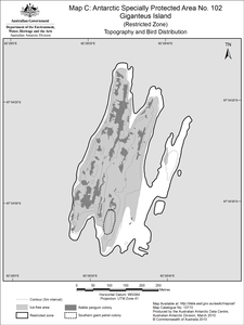
Map 13715: Antarctic Specially Protected Area No. 102
Giganteus Island (Restricted Zone)
Map C: Topography and Bird Distribution
Map details
| Map Number | 13715 |
| Title | Antarctic Specially Protected Area No. 102 Giganteus Island (Restricted Zone) Map C: Topography and Bird Distribution |
| Edition | 2 (Out of Date) |
| Previous edition | [Previous edition : 1] |
| Next Edition | [Next Edition : 3] |
| Scale | 1 : 5000 |
| Publication date | March 2010 |
| Publisher |
Australian Antarctic Division (Australia)
|
| Spatial coverage |
( 62.4828° -64.5706°)
,
( 62.5000° -64.5706°)
,
( 62.5000° -64.5772°)
( 62.4828° -64.5772°) |
| Projection | Universal Transverse Mercator |
| Physical size | 20 x 15 cm |
| Keywords | Rookery Islands |
Downloads
This is a digital map available for downloading.
Map Lists
No maps lists available.
Additional Information
| Horizontal datum | WGS84 |
| Vertical datum | Mean sea level |
| Nomenclature | Australian Antarctic Gazetteer |
Preview