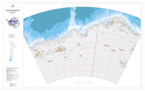
Map 13717: Operations Map: 10°E to 65°E
Map details
| Map Number | 13717 |
| Title | Operations Map: 10°E to 65°E |
| Edition | 1 |
| Scale | 1 : 2 000 000 |
| Publication date | May 2010 |
| Publisher |
Australian Antarctic Division (Australia)
|
| Spatial coverage |
( 10.0000° -65.0000°)
,
( 65.0000° -65.0000°)
,
( 65.0000° -77.0000°)
( 10.0000° -77.0000°) |
| Projection | Lambert Conformal Conic |
| Physical size | 82.5 x 134.5 cm |
| Keywords | Australian Antarctic Territory , Dronning Maud Land , Princess Astrid Coast , Princess Ragnhild Coast , Prince Harald Coast , Prince Olav Coast , Enderby Land , Kemp Land , Mac.Robertson Land , Topographic |
Downloads
This is a digital map available for downloading.
Map Lists
This map belongs to the following lists. Use the link on the list to see all maps belonging to that list
Additional Information
| Horizontal datum | WGS84 |
| Nomenclature |
Names in the Australian Antarctic Territory were sourced from the Australian Antarctic Gazetteer. Names in Dronning Maud Land were sourced from the SCAR Gazetteer. |
Preview