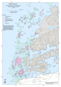
Map 13718: Vestfold Hills: Proposed Aerial Photography of Penguin Colonies 2009-10
Map 1
Map details
| Map Number | 13718 |
| Title | Vestfold Hills: Proposed Aerial Photography of Penguin Colonies 2009-10 Map 1 |
| Edition | 1 |
| Scale | 1 : 50 000 |
| Publication date | October 2009 |
| Publisher |
Australian Antarctic Division (Australia)
|
| Spatial coverage |
( 77.7683° -68.5094°)
,
( 78.1014° -68.5094°)
,
( 78.1014° -68.6869°)
( 77.7683° -68.6869°) |
| Projection | Universal Transverse Mercator |
| Physical size | 42 x 29.7 cm A3 |
| Keywords | - |
Downloads
This is a digital map available for downloading.
Map Lists
No maps lists available.
Additional Information
| Horizontal datum | WGS84 |
Preview