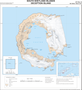
Map 13795: South Shetland Islands: Deception Island
Map details
| Map Number | 13795 |
| Title | South Shetland Islands: Deception Island |
| Edition | 6 |
| Previous edition | [Previous edition : 5] |
| Scale | 1 : 50 000 |
| Publication date | March 2010 |
| Publisher |
UK Antarctic Place-names Committee (United Kingdom)
|
| Spatial coverage |
( -60.7733° -62.8794°)
,
( -60.4556° -62.8794°)
,
( -60.4556° -63.0328°)
( -60.7733° -63.0328°) |
| Projection | Polar Stereographic |
| Physical size | 47.8 x 46.1 cm |
| Notes |
Provisional for the positioning of place names Not to be used for navigational purposes Insets: Sail Rock 1:10,000; Location diagram from BAS Misc 14, 2009 |
| Reference | APC Misc 18 |
| Keywords | Deception Island , Apc Misc 18 , Port Foster , Fumarole Bay , Whalers Bay , Neptunes Bellows , Mount Kirkwood , Mount Pond , Stonethrow Ridge , Telefon Ridge , Kendall Terrace , Lavebrua Island , Topographic |
Downloads
This is a digital map available for downloading.
Map Lists
No maps lists available.
Additional Information
| Horizontal datum | WGS84 |
| Nomenclature | BAT Gazetteer |
Preview