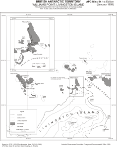
Map 13800: Williams Point: Livingston Island
Map details
| Map Number | 13800 |
| Title | Williams Point: Livingston Island |
| Edition | 1 |
| Scale | 1 : 83 333 |
| Publication date | January 1999 |
| Publisher |
UK Antarctic Place-names Committee (United Kingdom)
|
| Spatial coverage |
( -60.4167° -62.3333°)
,
( -60.0000° -62.3333°)
,
( -60.0000° -62.5500°)
( -60.4167° -62.5500°) |
| Projection | Polar Stereographic |
| Physical size | 36.5 x 28.7 cm |
| Notes |
Provisional edition for the positioning of place-names. Not to be used for navigational purposes. Based on: DOS 1:200,000 scale series, sheet W 62 60 (1968) |
| Reference | APC Misc 94 |
| Keywords | British Antarctic Territory , Mcfarlane Strait , Williams Point , Phelps Promontory , Topographic |
Downloads
This is a digital map available for downloading.
Map Lists
No maps lists available.
Additional Information
| Horizontal datum | WGS84 |
Preview