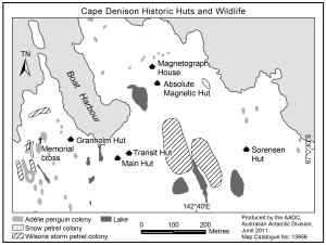
Map 13956: Cape Denison Historic Huts and Wildlife
Map details
| Map Number | 13956 |
| Title | Cape Denison Historic Huts and Wildlife |
| Edition | 1 |
| Scale | 1 : 10 000 |
| Publication date | June 2011 |
| Publisher | - |
| Spatial coverage |
(142.6533° -67.0047°)
,
(142.6750° -67.0047°)
,
(142.6750° -67.0103°)
(142.6533° -67.0103°) |
| Projection | Universal Transverse Mercator |
| Physical size | 7.5 x 10 cm |
| Notes | Map produced for 'Visitor site guide for Mawson's Huts and Cape Denison, East Antarctica'. |
| Keywords | Commonwealth Bay , Hut |
Downloads
This is a digital map available for downloading.
Map Lists
This map belongs to the following lists. Use the link on the list to see all maps belonging to that list
Additional Information
| Horizontal datum | WGS84 |
Preview